Appenzell Innerrhoden
| Kanton Appenzell Innerrhoden | |||
|
|||
 |
|||
| Coordinates | |||
| Capital | Appenzell | ||
| Population | 15,681 (12/2009)[1] | ||
| - Density | 91 /km² (235 /sq mi) | ||
| Area | 173 km² (67 sq mi) | ||
| Highest point | 2,502 m (8,209 ft) - Säntis | ||
| Joined | 1513 | ||
| Abbreviation | AI | ||
| Languages | German | ||
| Executive | Standeskommission (7) | ||
| Legislative | Landsgemeinde Grosser Rat (49) |
||
| Districts | 6 Bezirk | ||
| Website | AI.ch | ||
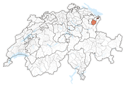
| View map of Appenzell Innerrhoden | |||
|---|---|---|---|
Appenzell Innerrhoden (German: Appenzell Innerrhoden; in English sometimes Appenzell Inner Rhodes) is the smallest canton of Switzerland by population and the second smallest by area, Basel-City having less area.
Contents |
History
The name Appenzell (Latin: abbatis cella) means "cell (i.e. estate) of the abbot". This refers to the Abbey of St. Gall, which exerted a great influence on the area. By the middle of the 11th century the abbots of St Gall had established their power in the land later called Appenzell, which, too, became thoroughly teutonized, its early inhabitants having probably been romanized Raetians. But as early as 1377, this portion of the abbots' domains formed an alliance with the Swabian free imperial cities and adopted a constitution of its own. The repeated attempts of the abbots to put down this independence of their rule were defeated in the battles of Vögelinsegg (1403), north-west of Trogen, and of the Stoss (1405), the pass leading from Gais over to Altstätten in the Rhine valley. In 1411 Appenzell was placed under the "protection" of the Swiss Confederation, of which, in 1452, it became an "allied member," and in 1513 a full member. Religious differences broke up the land after the Reformation into two portions, with Appenzell Ausserrhoden being the other half. Appenzell Innerrhoden was the last canton granting women the right to vote, in 1990.
Geography
Most of the canton is pastoral, this despite being mountainous. The Säntis peak in the Appenzell Alps is one of the main attractions of the canton. There are three small mountain lakes in the canton: Seealpsee, Sämtisersee and Fälensee.
Political subdivisions
In Appenzell Innerrhoden districts are the lowest administrative division: the canton is not subdivided in municipalities. Because of that, for firefighting, energy and water, the town Appenzell has a special-purpose municipality, the Feuerschaugemeinde.
The Canton is divided into 6 districts:
- Appenzell
- Gonten
- Oberegg
- Rüte
- Schlatt-Haslen
- Schwende
Government

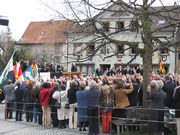
Appenzell is the capital of this canton. The constitution was established in 1872. Citizens from the canton assemble every last Sunday of April for the Landsgemeinde (general assembly) in a square in Appenzell, vote on laws and elect the Governing Council.
In 1991, following a decision by the Federal Supreme Court of Switzerland, Appenzell Innerrhoden became the last Swiss canton to grant women the vote on local issues.[2]
Demographics
The population of the canton (as of 31 December 2009) is 15,681.[1] As of 2007[update], the population included 1,510 foreigners, or about 9.76% of the total population.[3] Due to the split of Appenzell along religious lines, the population (as of 2000[update]) is nearly all Roman Catholic (81%), with a small Protestant minority (10%).[4]
Economy
Cattle breeding and dairy farming are the main agricultural activities: Appenzeller cheese is widely available throughout Switzerland. By the early 2000s, the idyllic countryside of Appenzell Innerrhoden apparently became popular with nudists, but at the 2009 Landsgemeinde the canton's residents voted to prohibit naked hiking. Violators will be fined.[5] It is common for cars rented in Switzerland to be registered in Appenzell Innerrhoden, and thus having license plates starting with "AI", because of the reduced tax on automobiles in this canton.
External links
- Official website (English)
- Official statistics
- List of castles and fortresses in Switzerland
- Säntis (German)
 Media related to Appenzell Innerrhoden at Wikimedia Commons
References
Notes
- ↑ 1.0 1.1 Swiss Federal Statistical Office, MS Excel document – Bilanz der ständigen Wohnbevölkerung nach Kantonen, Bezirken und Gemeinden (German) accessed 25 August 2010
- ↑ United Nations press release of a meeting of the Committee on the Elimination of Discrimination against Women (CEDAW), issued on the 14 January 2003
- ↑ Federal Department of Statistics (2008). "Ständige Wohnbevölkerung nach Staatsangehörigkeit, Geschlecht und Kantonen" (Microsoft Excel). http://www.bfs.admin.ch/bfs/portal/de/index/themen/01/02/blank/key/raeumliche_verteilung/kantone__gemeinden.html. Retrieved 2008-11-05.
- ↑ Federal Department of Statistics (2004). "Wohnbevölkerung nach Religion" (Interactive Map). http://www.bfs.admin.ch/bfs/portal/de/index/themen/01/05/blank/key/religionen.html. Retrieved 2009-01-15.
- ↑ Swiss canton bans nude hiking (Reuters, Mon Apr 27, 2009)
|
|||||

